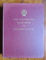
Illustrated Road Book of England and Wales with Gazetteer, Itineraries, Maps and Town Plans
The Automobile Association
| Publication Date |
1961 |
| Publisher |
The Automobile Association, |
| Binding |
Hardback |
| Condition |
Very good copy |
| SKU |
24737 |
| Notes |
Some slight, uneven sunned to cloth. Few faint, minor marks but generally very clean. A tight, square copy. |
Description
Hardback. Second post-war edition, illustrated, and with minor corrections. 480pp.+ maps. Includes: gazetteer with line drawings of places of interest and town centre plans for many places, routes and itineraries, ferry details, mileage chart, long list of literary associations, Bartholomew’s Road Atlas of England and Wales 60pp. It is extensively illustrated with hundreds of line drawings. Black and white frontis of Kilpeck church. A substantial and fascinating snapshot of road travel in the early 1960s which would be of great use to social historians or writers of historical fiction. Maroon cloth to boards with rounded corners to boards and pages. Gilt titles to front and to spine.
You may also be interested in books cross-referenced in the following areas:


